Navigation settings
The images displayed on this system may differ from actual ones.
Set items to display or guide item on navigation map screen.
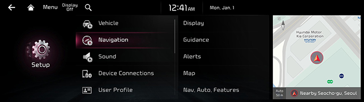
Move to Navigation setting screen
On the home screen, Press [Setup] > [Navigation]. Navigation screen is displayed.
|
|
Display
- On the navigation settings screen, press [Display].
|
|
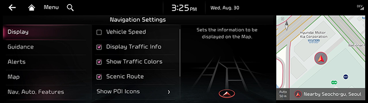
- Press the desired item.
Vehicle Speed
Select to always show the vehicle speed on the map screen.
Display Traffic Info
Sets whether to show traffic information on the 2D or 3D map view.
Show Traffic Colors
Color codes the flow of traffic on a route.
Scenic Route
Shows scenic route on the map.
Show POI Icons on Map
Sets the display of POI Icons.
Address Format
You can set address display method to [New Address Format] or [Old Address Format].
Fuel Price
Enable this option to display fuel prices for stations under the average fuel price.
Guidance
- On the navigation settings screen, press [Guidance].
|
|
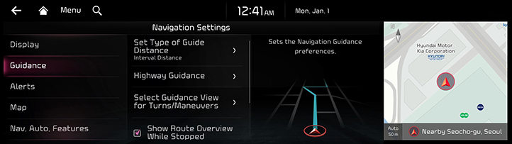
- Press the desired item.
Set Type of Guide Distance
Sets how to inform the remaining distance to next guidance location.
Highway Guidance
Activates the highway guidance.
Select Guidance View for Turns/Maneuvers
Sets how to display guidance locations.
Show Route Overview While Stopped
Shows the full route overview when stopped.
End Navigation Voice Guidance Near Destination
Finishes the voice guidance near the destination registered as a favorite location.
Alerts
- On the navigation settings screen, press [Alerts].
|
|
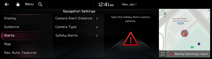
- Press the desired item.
Camera Alert Distance
- [Camera Alert Distance Depending on the Speed Limit]: Camera alert points are guides based on the vehicle speed.
- Camera Alert Distance [Local Roads]: Set the camera alert on a general road as [At 500m], [At 300m], [At 100m].
- Camera Alert Distance [Highway]: Set the camera alert on a highway as [At 1km], [At 700m], [At 300m].
Camera Type
You can set camera guide to [Speed/Signal],[Lane Change],[Speed (Portable Camera)] or etc.
Safety Alerts
- [Daytime]: Set the alert during daytime on [Speed Bump], [Accident-prone Area], [School Zone] and other cautious sections.
- [Night]: Set the alert during night time on [Speed Bump], [Accident-prone Area], [School Zone] and other cautious sections.
Map
- On the navigation settings screen, press [Map].
|
|
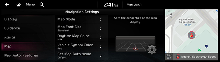
- Press the desired item.
Map Mode
You can set the information displayed on map.
- [Map View]: Sets the map view options to be used in the map at daytime and night.
- [Show Notification When Map View Changes]: Sets whether to show a notification when the map view changes between Daytime/night mode.
- [3D Buildings]: Select to show 3D buildings on the 3D map view.
- [Auto-scale]: Adjusts the map scale automatically.
Map Font Size
You can set the size of letter displayed on map to [Extra Large], [Large], [Standard].
Daytime Map Color
You can set the weekly map theme to [Milk], [Caffè Latte], [Mocha] or [Black].
Vehicle Symbol Color
You can set the color of vehicle symbol that displays the current location on the map.
Set Map Auto-scale
You can set auto scale based on the vehicle speed.
Nav. Auto. Features
- On the navigation settings screen, press [Nav. Auto. Features].
|
|
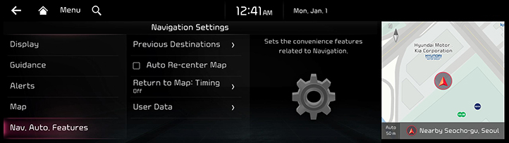
- Press the desired item.
Previous Destinations
Sets the Previous Destinations preferences.
Auto Re-center Map
Automatically re-center the map at the current vehicle position after viewing other locations on the map.
Return to Map: Timing
You can set whether to automatically return to navi screen to [20 sec], [10 sec], [5 sec], [Off]. This feature is not available while using phone projaction.
User Data
- [Import Favorites and Previous Destinations from USB]: Imports recent data from favorites/recent destinations exported to a USB storage into the terminal.
- [Export Favorites and Previous Destinations to USB]: Exports favorites/recent destinations stored in the terminal into a USB storage.
|
,Note |
|