Configuring the navigation settings
You can configure the navigation settings to customise the navigation operations, screen display, and other settings. You can also export or import the location data.
- For details on how to use navigation functions, see the "Navigation" chapter. ▶ See "Navigation."
- On the All menus screen, press Settings ▶ Navigation.
The navigation settings screen appears.
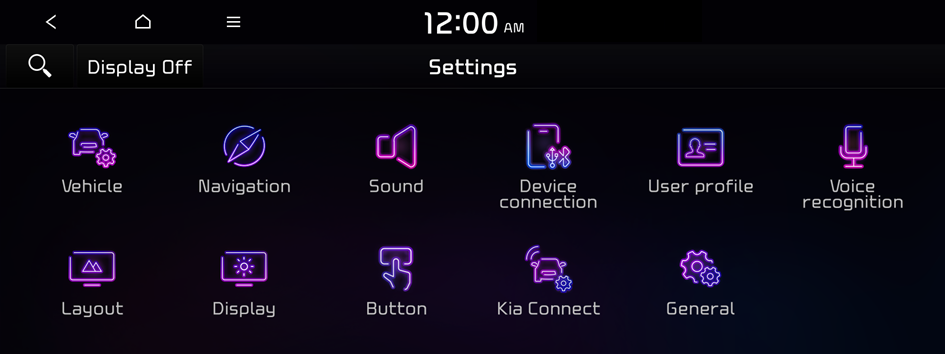
Type1
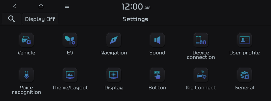
Type2
- The screen may differ depending on the vehicle model and specifications.
- If the vehicle is type 2, it is possible to change the graphic theme to white or black. ▶ See "Graphic themes (if equipped)."
- Configure the settings required:
- Press
 ▶ Search for settings or press
  and enter a keyword to search for a setting item. You can also search for a setting item by voice.
Display
You can set the information to display on the navigation map screen.
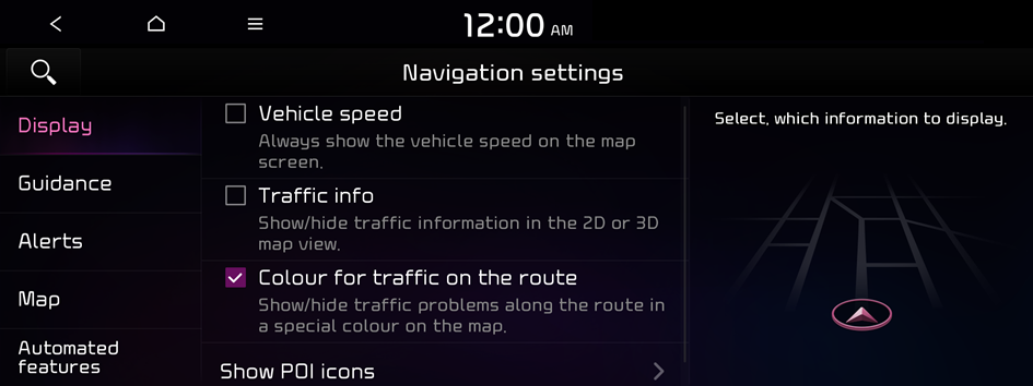
- The screen may differ depending on the vehicle model and specifications.
Vehicle speed
Displays the vehicle speed on the map.
Traffic info
Displays traffic information on the map.
Colour for traffic on the route
Displays the route guide line in colour depending on the traffic conditions.
Show POI icons
Set to display nearby places on the map.
Guidance
You can configure the navigation guidance settings.
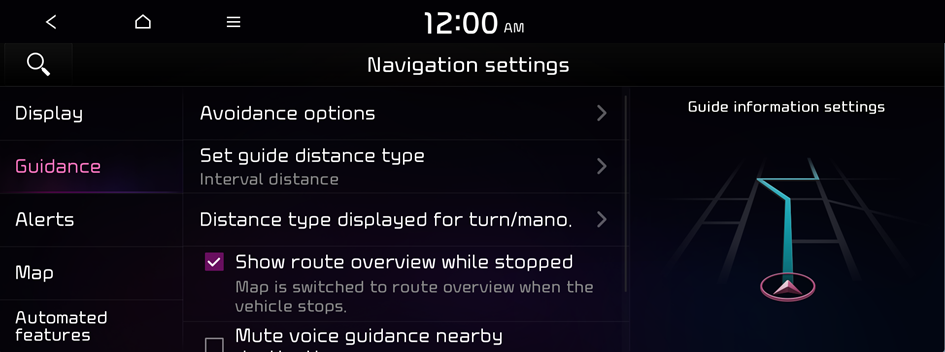
- The screen may differ depending on the vehicle model and specifications.
Route options or Avoidance options (if equipped)
You can set desired route search options.
Set guide distance type
Set to display the distance to the destination during guidance.
- • Interval distance: Displays the distance as the one between different zones.
- • Cumulative distance: Displays the distance as the one between the current location and target location.
Distance type displayed for turn/mano.
Set the information to display on the navigation map screen while driving.
- • Show route details: Set to display detailed information on the Map screen, such as moving directions and lane change.
Show route overview while stopped
Set to display the route overview when the vehicle is stationary.
Mute voice guidance nearby destination
If the set destination is a saved place, voice guidance is turned off when the vehicle gets closer to the destination.
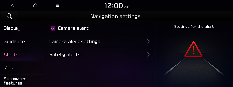
Alerts
You can set to activate drive assist function when needed for safety.
- The screen may differ depending on the vehicle model and specifications.
Camera alert
You can enable or disable the traffic enforcement camera alerts.
- The speed limits displayed on the navigation system may differ from the actual road conditions.
Camera alert settings
You can set when to receive alerts against and voice descriptions about traffic enforcement cameras.
- • Alert distance depending on the speed limit: When the Alert distance depending on the speed limit function is off, the time when to get guidance on traffic enforcement cameras on Alert distance (motorway) can be selected.
Safety alerts
Set the type of zone to get safety alerts for and specify the time (Daytime/Night) when to get safety alerts.
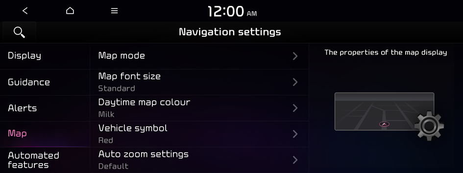
Map
You can set the items to display on the map.
- The screen may differ depending on the vehicle model and specifications.
Map mode
Set the map display mode.
- • Map view: Set the navigation map display mode. To fix the top of the map screen to north, select 2D North up. To automatically rotate the map screen based on the driving direction, select 2D heading up. If you select 3D heading up, the map screen is displayed in 3D mode and automatically rotates based on the driving direction.
- • 3D buildings: Displays major buildings on the map in three dimensions.
- • Auto zoom: Automatically changes the scale of the map.
Map font size
Set the navigation map font size.
Daytime map colour (if equipped)
Set the navigation map theme colour.
Vehicle symbol
Set the icon type to display your current location on the map.
Auto zoom settings
You can set the scale, which is automatically adjusted based on the vehicle speed.
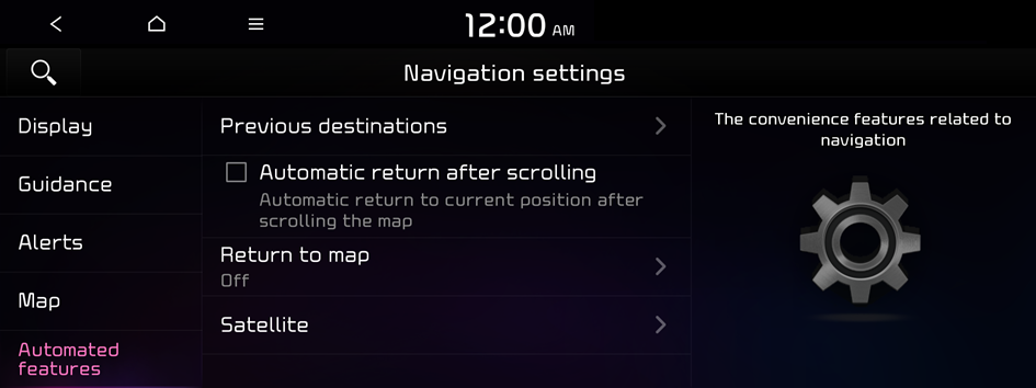
Automated features
You can configure navigation options, e.g., exporting or importing places from and to Saved Places.
- The screen may differ depending on the vehicle model and specifications.
Previous destinations
Set to automatically save the previous destination and display the previous destinations when the navigation system starts.
- • Save previous destinations: The previous destination is automatically saved.
- • Display previous destinations when entering the map screen: When the navigation system starts, the list of recent destinations appears on a pop-up screen.
Automatic return after scrolling
Set the system to automatically display the current location when 15 seconds elapses after dragging and moving to another position on the map.
Return to map
Set the system to automatically display the map screen after a specific period of time when switched to the Radio/Media mode screen while using the navigation.
- This function works while driving once a destination has been set.
- This function is not available on the phone projection screen.
My data (if equipped)
Import location data from a USB device to the system, or export the data on the system to a USB device.
- When importing or exporting the location data, you can use only the USB device formatted in exFAT, FAT16/32, or NTFS.
- • Import favourites and previous destinations from USB: You can import saved place and destination information, saved in your USB device, to the system.
- Previous information saved in the system will be deleted.
- While importing from a navigation system that uses a different coordinate system, the locations may appear differently.
- • Export favourites and previous destinations to USB: You can export saved place and destination information, saved in the system, to your USB device.
- Previous information saved in the USB device will be deleted.
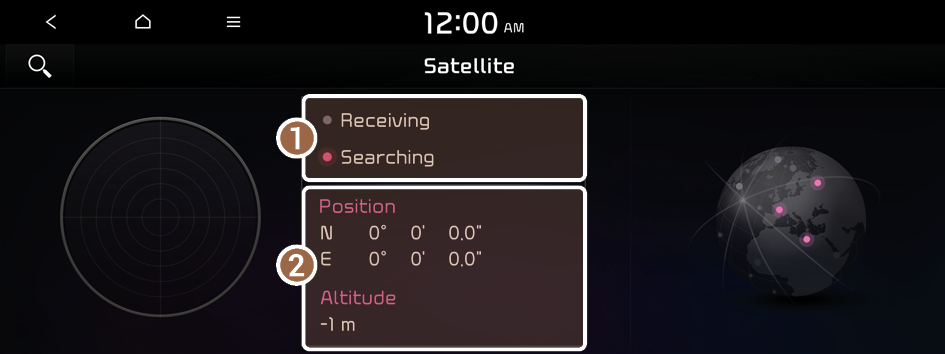
Satellite
Check the GPS satellite status and coordinates of the current location.
- The screen may differ depending on the vehicle model and specifications.
The following information appears:
- Check the reception status of the satellite signals.
- • Receiving: Satellite signals are being received and the current location is recognised.
- • Searching: The system is scanning the satellite signals.
- Check the current location.


