Starting navigation
Navigation general information
Safety precautions
- You cannot keep your eyes on the road if you operate the navigation while driving, which may lead to a traffic accident. Therefore, do not operate the device while driving.
- Do not view the navigation screen continuously while driving. Doing so may cause a traffic accident.
- Always comply with the traffic regulations when driving. Relying solely on the navigation guidance may cause you to violate the traffic regulations and lead to a traffic accident.
- Some features are not available during driving for your safety.
- Road, location or facility information may not be up-to-date or may be missing in some locations.
- The specified route is a reference to guide you to the nearest possible spot to the destination. The suggested route is not always the shortest or fastest route or a route with the least amount of congestion.
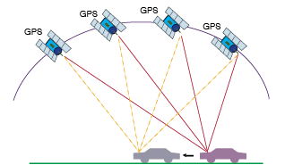
- The vehicle location mark may incorrectly indicate the vehicle’s current location. The vehicle location mark can be off due to conditions of the satellites or vehicle (driving area and driving conditions). Also, this may happen when you drive on a new road and the map does not yet have its data. However, as you continue to drive, the navigation corrects the inaccurate location mark automatically in a while by using map matching or GPS information. (In some cases, it may take several minutes to correct.)
- This system uses GPS information, various sensors, road maps and other data to mark the current location. However, if the satellite signal accuracy is poor or waves can only be received from fewer than two satellites, errors can occur.
- Set the sound volume at an appropriate level when you drive. Failure to do so may lead to a traffic accident.
- Voice guide may be inconsistent with the actual conditions. Therefore, always observe the traffic regulations while driving.
|
,Reference |
|
About map
information on roads, locations, facilities and fees may differ from the actual conditions depending on the point of map data update.
The tollgate fare prices announced on korea expressway corporation’s policies may differ from the actual prices. (weekend premium/Hi-pass discounts, etc.)
|
,Reference |
|
If GPS information is not available
GPS information may not be available in the following cases.
- Satellite signals are blocked by buildings, tunnels or other obstacles.
- Satellite signals are blocked by objects placed on the GPS antennas.
- Satellites stop transmitting signals. (The satellites are controlled by the tracking control center in the US and sometimes stop transmitting signals due to maintenance.)