Navigation
This menu describes navigation settings.
Display
This menu is used to change the display environment settings.
- Press [SETUP] > [Navigation] > [Display].
|
|
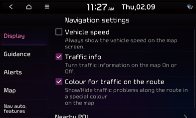
- Select the desired items.
- [Vehicle speed]: Sets to display vehicle speed. In some model of the vehicles, the GPS speed is displayed and it may differ from the cluster speed.
- [Traffic info]: Turns the traffic information on the map on or off.
- [Colour for traffic on the route]: Check or uncheck to show or hide traffic problems along the route in a special colour on the map.
- [Nearby POI]: Selects the POI information to display on the map.
Guidance
This menu is used to change the guidance settings.
- Press [SETUP] > [Navigation] > [Guidance].
|
|
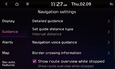
- Select the desired items.
- [Detailed guidance]
- [Show route details]: Sets whether to display the detailed guidance view or not.
- [Show speed limits]: Sets whether to display the speed limit or not.
- [Distance unit]: Sets the distance unit.
- [Display guidance information on top of screen]: Sets whether to display guidance information on top of screen.
- [Set guide distance type]: Sets the distance display method to the guidance position to [Interval distance] or [Cumulative distance].
- [Navigation voice guidance]
- [Mute voice navigation nearby destination]: Sets whether to Mute Voice navigation upon approaching the destination area, if location has been previously registered as one of the [Saved places].
- [Border crossing information]: Sets whether to display the border crossing information or not.
- [Show route overview while stopped]: Sets route overview to be displayed while stopping.
- [Previous destinations settings]
- [Save previous destinations]: Selects to automatically save a location in previous destinations.
- [Save time stamp in previous destinations]: Sets to save the time you used the previous destinations.
- [Show previous destinations on start]: Selects to show previous destinations after navigation starts up.
- [Recommended destinations]: Sets whether to display recommended destination.
Alerts (If equipped)
This menu is used to change the camera alert settings. This function is available only when UVO is activated.
- Press [SETUP] > [Navigation] > [Alerts].
|
|
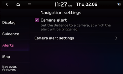
- Select the desired items.
- [Camera alert]: Sets the camera alert enable.
- [Camera alert settings]: Adjusts camera alert settings.
- [Alert distance depending on the vehicle speed]: Sets the alert distance depending on the speed limit.
- [Alert distance (General)]: Sets the alert distance in the general road.
- [Alert distance (Motorway)]: Sets the alert distance in the motorway.
Map
This menu is used to change the map settings.
- Press [SETUP] > [Navigation] > [Map].
|
|
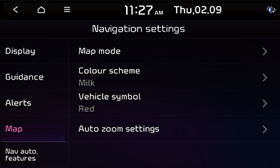
- Select the desired items.
- [Map mode]: Sets the type of the map.
- [Map view]: Sets the map view style.
- [3D buildings]:Sets whether to display 3D buildings in the 3D map view.
- [Auto zoom]: Sets whether to adjust the scale automatically.
- [Colour scheme]: Sets the map colour.
- [Vehicle symbol]: Sets the vehicle symbol style.
- [Auto zoom settings]: Sets the map scale to be adjusted automatically based on the vehicle speed.
Nav auto. features (If equipped)
- Press [SETUP] > [Navigation] > [Nav auto. features].
|
|
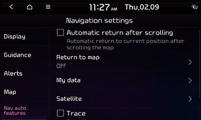
- Select the desired item.
- [Automatic return after scrolling]: Automatically returns to the vehicle position on the map after scrolling.
- [Return to map]: After the selected time, the system automatically switches from radio/media to the navigation map screen, if a route is active.
- [My data]: Saved places/previous destinations can be shared between compatible vehicles using a USB device.
- [Import saved places/previous destinations from USB]: This function is used to import the address book in the USB device to the navigation system.
- [Export saved places/previous destinations to USB]: This function is used to export the address book in the navigation system to the USB device.
- [Satellite]: Displays the satellite status.
- [Trace]: Shows the trace.
- [Reset trace]: Resets the trace.
|
,Note |
|